OpenStreetMap

Users' Diaries

Recent diary entries

collaborative live mapping of regions affected by rain in Rio Grande do Sul - Brazil.

Today we are going to map the area that was affected by the rains in the state of Rio Grande do Sul, there will be a live broadcast at 7:00 pm where everyone can map and help with mapping the affected area.

task link. MAPPING OF ROADS IN THE AREA AFFECTED BY THE FLOOD OF THE PARDO RIVER IN CANDELÁRIA-RS https://tasks.hotosm.org/projects/16696

Youtube: https://www.youtube.com/watch?v=3Wm-nTnCRaQ&t=7s

organization: UFV youthmappers UMBRAOSM

live collaborative mapping in the affected areas of RS

Location: Jardim Botânico, Porto Alegre, Região Geográfica Imediata de Porto Alegre, Metropolitan Region of Porto Alegre, Região Geográfica Intermediária de Porto Alegre, Rio Grande do Sul, South Region, Brazil

Greetings!

We are thrilled to share some exciting news from OpenStreetMap Bangladesh (OSMBD). For the first time ever, the OSM Bangladesh community has successfully formed an elected Executive Committee, consisting of a team of dedicated individuals who will guide our community’s activities and initiatives.

We are proud to introduce the newly elected Executive Committee:

President: S M Sawan Shariar

Vice-President: Atikur Rahman

Secretary: Samsul Arafin

Treasurer: Nahid Ferdous

Member-at-large: Mehedi Hasan Ovi

Member-at-large: Afia Tahmin Jahin

Member-at-large: Laila Sharmin Nova

Alt text

The committee is committed to upholding OSMBD’s core values of collaboration, community-driven initiatives, openness, and accessibility. Our focus is on promoting the use and development of OpenStreetMap in Bangladesh, building and maintaining a comprehensive map of Bangladesh that is freely accessible, and supporting OSM groups and initiatives through training, events, and more.

We would be delighted to collaborate with you on OSM-related projects in Bangladesh. If you need any assistance or guidance, or if you would like to collaborate on OSM-integrated activities, please do not hesitate to reach out to us at our central email communication address: info.osmbd@gmail.com

For ongoing updates and discussions, we invite you to subscribe to our Talk BD channel through the following link: https://lists.openstreetmap.org/listinfo/talk-bd

We appreciate your support and collaboration in advancing the use of OpenStreetMap in Bangladesh and look forward to working with you to achieve our shared goals.

Thank you for standing with the OpenStreetMap Bangladesh community.

Cheers!

Sawan Shariar

President (Elected), OpenStreetMap Bangladesh

Location: Monipuri Para, Tejgaon, Dhaka, Dhaka Metropolitan, Dhaka District, Dhaka Division, 1215, Bangladesh
Posted by Enock4seth on 6 May 2024 in English.

Hello OSM World,

Welcome to #WOSMinGhana 000

I am starting a series of OSM Diary posts title Worst of OSM in Ghana, inspired by best and worst of OSM posts I have seen. The idea is to share one photo per week (I hope I can keep up, feel free to share any you might have seen in Ghana too :D). i.e. Before and After (if I am able to improve or fix it)

Sometimes you come across very interesting mapping activities and data and you are out of words. Myself and other volunteer mappers have taken screenshots of worst contributions on OSM in Ghana over the years and then proceeded to improve them / notify mappers or organizations.

Why talk about the worst not the best? Highlighting these worst mappings might help create more awareness about what we put out there as part of individual or organized mapping activities.

This is purposely to help improve OSM data in Ghana in these areas by myself or other mappers and for us all to beware of when mapping.

Looking forward to the coming weeks.

Location: Kwameteng, Sekyere Central District, Ashanti Region, Ghana
Posted by TrickyFoxy on 6 May 2024 in Russian (Русский). Last updated on 7 May 2024.

Написал юзерскрипт для Tampermonkey, добавляющий несколько полезных мелочей:

  • Удалятель точек
  • Улучшенная работа с заметками
  • Компактная история объектов
  • HDYC в профиле пользователей
  • Компактная информации о правке
  • Кнопка отката

🔫 Удалятель точек

📝 Улучшенная работа с заметками

  1. При открытии заметок теперь вы можете включить спутниковые снимки
  2. Появилась кнопка с быстрым комментарием к заметке
  3. Появилась кнопка, которая с помощью Overpass показывает состояние карты на момент создания заметки
  4. Убирается мещающая оранжевая обводка около актиной заметки

🕒 Компактная история объектов

  1. Показывает на странице истории только изменившиеся теги
  2. Скрывает версии без изменений и скрытые DWG

🪪 HDYC в профиле пользователей

Но только в Firefox и с отключением защиты от отслеживания

🔍 Компактное описание правки и кнопка отката

также компактнее стала вкладка История.


Как установить

  1. Установите расширение Tampermonkey
  2. После откройте файл со скриптом

p.s. Несмотря на то, что юзерскрипты должны работать в любых браузерах одинаково, Chrome отличился: спутниковые снимки и HDYC работать в нём не будут. Переходите на Firefox :)

p.p.s. Функции можно отключать в настройках скрипта, нажав на значок расширения

Introduction

Humanitarian logistics is defined as the process of planning, implementing and controlling the efficient, cost-effective flow and storage of goods and materials, as well as related information, from the point of origin to the end of consumption to alleviate the suffering of vulnerable people

Its Extent and Impacts

The humanitarian logistics of peace operations in sub-Saharan Africa is one of the most challenging operations in the contemporary world. Faced with this reality, several scenarios challenge conventional logistical practices translated into humanitarian efforts on the African continent. Several events have led Africa to the current situation, whose conflicts have worsened the case in some countries. In this scenario, three countries stand out on the African continent: South Sudan (SS), the Central African Republic (CAR) and the Democratic Republic of Congo (DRC).

1.Positive Impacts

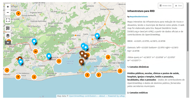
Data Collection and Mapping - GIS technology is used to collect, analyze, and visualize geospatial data. Humanitarian organizations in South Sudan leverage GIS to map various elements such as population distributions, events, infrastructure, health facilities, water sources, and more. This comprehensive mapping enables organizations to identify vulnerable areas and better understand the needs of the population.

Situation and Needs Assessment - OSM aids in conducting rapid situation assessments and needs analyses during crises and emergencies. Each region in South Sudan is prominently represented by one or the other ethnic and communal group, each with its own methods of action. By overlaying various data layers, including demographic, environmental, and public infrastructure, organizations can quickly identify areas that require immediate specialized attention and allocate resources accordingly.

Resource Allocation and Planning - OSM enables efficient resource allocation. Humanitarian agencies can determine the best locations for setting up relief distribution centers, medical clinics, or emergency shelters based on the data. This leads to more effective and targeted assistance.

2.Reccomendations

Collaborative efforts between various organizations and government agencies in Democratic Republic of Congo have to leverage Open Street Mapping for humanitarian work, contributing to more effective disaster response, and conflict mitigation. These partnerships have been crucial in addressing the complex challenges in the region.

Link

My profile

Image

Ça faisait un moment que je n’avais plus fait un update, mais mieux vaut tard que jamais.

Pour faire simple, il y a pas mal de choses que j’ai ajouté/corrigé sur OSM depuis la dernière fois (le boulevard urbain de Seraing et ses pistes cyclo-piétonnes, revêtement d’un paquet de rues/chemins/sentiers sur Seraing également, des installations éoliennes sur Engis, divers sentiers/chemins sur Neupré + utilisation des sols, etc) et parfois j’ai enregistré la session qui va avec, mais je me rends compte que ce n’est pas très intéressant ou je suis trop brouillon dans mes explications ou c’est un update trop ambitieux (comprendre la vidéo finale sera trop longue), ce qui me pousse à ne pas utiliser l’enregistrement ou le couper au milieu pour me concentrer sur ce que je fais sur OSM à la place (c’est le plus important après tout 😉).

Un autre changement important est que j’utilise un nouvel éditeur vidéo depuis le dernier update. Jusqu’ici, j’utilisais Openshot qui est assez simple d’utilisation mais devenait un peu basique à mon goût, et maintenant je suis sur Kdenlive qui me permet d’éditer mes vidéos de manière plus précise et de couper les temps-morts le plus possible (sans doute au prix de la fluidité parfois 😅).

Évidemment, il y a plus que trois vidéos cette fois-ci, mais c’est aussi sur une période de trois mois. J’ai aussi fait sur OpenHistoricalMap, mais je ne vais plus les mentionner ici vu que c’est OSM et pas OHM.

Améliorons Flémalle (sur OpenStreetMap) - Épisode 7 (Ivoz-Ramet et ses “problèmes”) - Version Live de cet update où je corrige divers “problèmes” sur Ivoz-Ramet

Améliorons Seraing (sur OpenStreetMap) - Épisode 32 (La quête des bornes continue!) - Version live de cet update qui est le résultat de ma première sortie VTT depuis mon opération… et mon pneu avant crevé 😡

Améliorons Seraing (sur OpenStreetMap) - Épisode 33 (Les aléas d’un déménagement) - Version live de cet update où je modifie deux rues et ajoute quelques parkings pendant que je parle de mon déménagement qui prend un peu son temps (ce n’est pas encore fait 😉)

Améliorons Seraing (sur OpenStreetMap) - Épisode 34 (Faisons un tour dans les bois) - Version live de cet update où je modifie/donne des précisions sur un bon paquet de rues/chemins/sentiers après une nouvelle sortie VTT

Améliorons Seraing (sur OpenStreetMap) - Épisode 35 (Le Bois de l’Abbaye et… Batman?) - Version live de cet update où je fais quelques changements après une visite improvisée dans ce bois

Améliorons Seraing (sur OpenStreetMap) - Épisode 36 (Les sentiers du Bois de la Vecquée) - Version live de cet update où j’ajoute un certain nombre de sentiers dans une portion du Bois de la Vecquée après une autre sortie VTT

Comme vous l’aurez compris, je n’essaie plus de suivre un rythme particulier pour le moment et les vidéos sont un peu plus rares en conséquence. Fatalement ces updates vont suivre la même logique, mais je posterai dès que j’ai 3-4 nouvelles vidéos à proposer.

A+ 😁

Location: 4100, Ougrée, Seraing, Liège, Wallonie, Belgique

아래 풍력발전기들은 위성사진상 풍력발전기인 건 맞으나, 어느 발전소인지 불명확한 것들임. 아마도 발전기 설치만 하고 계통병입을 아직 안 해서 EPSIS에 집계가 안 되고 있는 상황인 것으로 여겨짐. 추후 EPSIS에 노출되는 대로 정리 및 추가할 예정.

노드번호 Ref 위도 경도 구좌읍 월정리 node/6740186186 n.a. 33.5168579 126.7594851

구좌읍 김녕리 node/7641971542 n.a. 33.5587855 126.7711681 node/7641971500 n.a. 33.5633738 126.7724564

홍성군 node/9196588574 n.a. 36.5196404 126.4383888

부안군 node/11336347287 n.a. 35.5804069 126.665816 node/11336347288 n.a. 35.5804614 126.6656966 node/11336347289 n.a. 35.5805934 126.6656148 node/11336347290 n.a. 35.5807025 126.665584 node/11336347291 n.a. 35.5808432 126.66558

울릉군 node/10805235767 n.a. 37.5156583 130.815123

구좌읍 행원리 node/10763132616 n.a. 33.5540301 126.821713 node/6740186185 n.a. 33.5164777 126.7595529 node/3753982805 n.a. 33.5378955 126.7886977

태안군 node/10236801603 소형 발전 36.7694299 126.304618

해남군 화산면 삼마리 node/6979989839 n.a. 34.4369591 126.4321187 node/6979989840 n.a. 34.436909 126.4320674 node/6979989841 n.a. 34.4368105 126.4320219 node/6979989842 n.a. 34.4367229 126.432204 node/6979989843 n.a. 34.4367886 126.4322799 node/6979989844 n.a. 34.4368496 126.4323444 node/6979989845 n.a. 34.4366369 126.4323595 node/6979989846 n.a. 34.4366979 126.4324335 node/6979989847 n.a. 34.4367573 126.4324999 node/6979989848 n.a. 34.4366181 126.4325568 node/6979989849 n.a. 34.4372172 126.4326744 node/6979989850 n.a. 34.4374252 126.4327275 node/6979989851 n.a. 34.4365847 126.4330987 node/6979989852 n.a. 34.4370462 126.4325335

거창군 북상면 node/4483840546 n.a. 35.7911736 127.704751

不渲染landuse=religious的名称与宗教种类图标

根据wiki,landuse=religious用于标注整座庙宇的占地,而amenity=place_of_worship用于标注实际进行礼拜所用的建筑、广场等。然而,Carto图层只会对后者渲染名称和宗教种类图标。在西方,教堂、清真寺等往往是一栋大建筑,于是只要给他加上amenity=place_of_worship,就能顺利把名称和一个图标显示在地图上了。然而,东亚的宗教场所大多是多栋殿宇、房屋组成的院落,各有其名,其中并没有一个直接冠以该宗教场所名称的主体建筑。 这就导致,按照wiki要求标注的话,Carto图层上根本看不到寺院的名称,而如果画了建筑的话,会看到密密麻麻的宗教图标(每栋殿堂一个),没画的话则连宗教图标都没有。

不渲染单独的attraction=

该标签用于标注游乐设施,其中attraction=animal用于标注动物园的展区。根据wiki,attraction=不是tourism=attraction的子项,不用加tourism=attraction,iD的预设也是单独的标签。 但在Carto图层中,单独的attraction=是不渲染的。这导致很多编辑者标注游乐设施时同时加了tourism=attraction。

不渲染标为区域的place=farm和amenity=research_institute

我是在画农场时遇到的。据wiki,二者分别用来标记用于生产的和用于研究或学术目的的农场。有的农场有明确的围墙包围了田地和院落,只把名字写在landuse=farmyard区域不甚妥当。但把名称写在这两个标签上的话,在Carto图层是看不到这里有农场的。 此外,自然还有别的许多研究所也都不渲染出来。

県内には砂浜が3つある。
1つは市内、もう1つは南の県境、最後1つは北の方。
この前市内のところに行ってきた。
結論から言うと、ちゃんと砂浜ではあったが、あまりおすすめできない場所であった。
数時間滞在すればそのうち出るだろうが、ポケストがないあそこに長時間滞在はしたくない。
なお、南の県境の方はゲット報告を見かけた。
自分はウミディグダはそのうちイベントでばらまかれるのを待とうと思う。

Hoje me dediquei a explorar mapas antigos, cada um repleto de histórias e segredos de eras passadas. Em especial, fiquei fascinado por um mapa da Era dos Descobrimentos, detalhando não só as terras conhecidas mas também as misteriosas e inexploradas. Foi uma jornada visual e intelectual através das coordenadas que moldaram a compreensão do mundo naquela época.

Um dos mapas, datado do século XVII, mostrava a Europa com suas cidades bem definidas, mas ao se aventurar para regiões mais distantes, as linhas tornavam-se conjecturas cheias de criaturas míticas. As coordenadas de Lisboa, por exemplo, estavam precisamente marcadas em 38.7223° N, 9.1393° O, uma janela para o ponto de partida de muitas das viagens marítimas históricas.

Esse mapa me levou a refletir sobre como os cartógrafos daquela época utilizavam as coordenadas disponíveis para mapear o conhecido e o desconhecido. Eles serviam não apenas como guias geográficos, mas também como narrativas visuais dos limites do mundo explorado. Assim, cada linha e cada número no mapa contam mais do que uma localização; eles narram as ambições, os medos e as maravilhas de uma era de descobertas. A cada coordenada revelada, percebi o quanto ainda há para descobrir sobre nosso passado e como ele moldou o presente.

Location: 38.722, 9.139

Hoje comecei uma exploração virtual, guiada pelos mapas extensivos e movidos pela comunidade do OpenStreetMap. É fascinante como um esforço coletivo de todo o mundo pode se unir para mapear cada viela, rua e caminho com tanta granularidade detalhada. Esta jornada de código aberto me lembrou do entusiasmo pela descoberta, um sentimento que busco frequentemente, tanto online quanto offline.

Interessantemente, enquanto navegava por diferentes regiões no mapa, refleti sobre como a exploração não se limita a viagens físicas. Pode ser também sobre se aventurar em novas experiências ou revisitar territórios familiares com uma nova perspectiva. Isso é bastante semelhante a explorar o vasto mundo do entretenimento e jogos online, como os apresentados em Cassinos no Brasil. Assim como o OpenStreetMap revela novas vistas do mundo físico, Cassinos no Brasil desvenda uma paisagem vibrante e dinâmica de jogos e entretenimento, cada um oferecendo uma emoção e experiência única.

Seja mapeando uma nova trilha para caminhada ou experimentando um novo jogo, a alegria de descobrir novas facetas do mundo é infinitamente gratificante.

Location: Condomínio Quinta dos Ipês, Quinta dos Ipes, São Sebastião, Região Geográfica Imediata do Distrito Federal, Região Integrada de Desenvolvimento do Distrito Federal e Entorno, Região Geográfica Intermediária do Distrito Federal, Distrito Federal, Região Centro-Oeste, 71680-384, Brasil

Oficina para turma do Centro de Investigaciones en Geografía Ambiental, da Universidad Autónoma de México - CIGA-UNAM


A convite, a Dra. Raquel Dezidério Souto (IVIDES.org) realizou oficina sobre criação de web maps com uMap e dados do OpenStreetMap (OSM) para uma turma do Centro de Investigaciones en Geografía Ambiental, da Universidad Nacional Autónoma de México, campus de Morelia, como parte do curso PACES.

A oficina abrangeu uma parte conceitual e outra, prática. O conteúdo abrangeu uma apresentação dos conceitos relacionados a web mapping; características, modelo de dados, editores e APPs do OSM; e características, vantagens e limitações do uMap, como solução para web mapping.

Na parte prática, foi mostrado como criar um web map, sendo necessário apenas criar uma conta de usuário no OSM. Como exemplo, foi demonstrada a importação de dados de um arquivo .csv como uma camada estática no uMap e a criação de uma camada dinâmica, que recupera dados automaticamente, por meio de uma instrução em Overpass QL. Além de comentários sobre permissões de edição e visualização do web map e peculiaridades relativas à aparência dos objetos no produto final.

A instrução em Overpass QL disponibilizada para recuperação automática de escolas que já estão mapeadas no OSM e visualização com camada dinâmica no uMap pode ser adaptada para outros objetos geoespaciais, como hospitais ou supermercados, por exemplo.


https://overpass-api.de/api/interpreter?data=[out:json][timeout:25];
(node["amenity"="school"]({south},{west},{north},{east}););out body;>;out center skel qt;

IVIDES.org® é uma marca registrada.


A gravação da sessão pode ser encontrada em:

Parte 1 - conceitual - canal do IVIDES.org® no YouTube

Parte 2 - prática - canal do IVIDES.org® no YouTube


https://ivides.org/wp-content/uploads/2024/05/img2-1.png

https://ivides.org/wp-content/uploads/2024/05/screenshot_mapa.png


IVIDES_logo

Location: Tenencia Morelos, Morelia, Michoacán, 58341, México

Welcome to my fifth (and a half) OpenStreetMap NextGen development diary.
Tomorrow, I’m returning home and I’ll be able to resume work at full speed 🔥.

This is a short edition of the development diary.

🐙 This project is open-source and publicly available:
https://github.com/Zaczero/openstreetmap-ng

Intro

For the past 13 days I have been on a journey of finding a new place to rent. Without my home office, I wasn’t able to become productive. The place I’m staying at doesn’t have a good office spot and being on my laptop doesn’t help. However, I am now very motivated to get back to work and push even harder!

May Will Be Big

At the end of May, OpenStreetMap-NG will include necessary functionality to run on a testing server, as well as to invite new contributors into the project. Starting with 6th of May, I won’t have any time-consuming plans for this month so I’ll do my best to wrap everything up. What’s exactly left has been described in Diary #5 Short-Term Development Plan. I have already started to prepare the All-in-One Contributor Guide which will also be finished up (it currently lacks backend/frontend-specific guides). This is going to be the first major milestone of the project!

Project Sponsors 🏅

I was happily surprised to see new faces even during my lower activity period. I will do everything to deliver the promised results. As always, thank you for supporting the project, monetarily, and with staring the project on GitHub!

Currently, the project is sponsored by 13 people!
Five private and four public donors on Liberapay, and four public on GitHub Sponsors.

Disclaimer

This project is not affiliated with the OpenStreetMap Foundation. It’s an independent and community-sponsored initiative.